Paper # IJGCH_1_4_1 dell'International Journal of Geoengineering Case Histories.
Autori
Giuseppe Lanzo, Professor, University of Rome, Italy
Giuseppe Di Capua, INGV Rome, Italy
Robert E. Kayen, USGS Menlo Park, USA
D. Scott Kieffer, Professor, Graz University of Technology, Austria
Edward Button, ETH Zurich, Switzerland
Giovanna Biscontin, Professor, Texas A&M University, USA
Giuseppe Scasserra, University of Rome, Italy
Paolo Tommasi, CNR-IGAG, Rome, Italy
Alessandro Pagliaroli, CNR-IGAG, Rome, Italy
Francesco Silvestri, Professor, University of Naples, Italy
Anna d'Onofrio, Professor, University of Naples, Italy
Crescenzo Violante, CNR-IAMC, Naples, Italy
Armando Lucio Simonelli, Professor, University of Sannio, Benevento, Italy;
Rodolfo Puglia, INGV, Milan, Italy
George Mylonakis, Professor, University of Patras, Greece
George Athanasopoulos, Professor, University of Patras, Greece
Vasil Vlahakis, Graduate Student, University of Patras, Greece
Jonathan P. Stewart, Professor and Vice Chair Civil and Environmental Engineering Department, University of California, Los Angeles, USA
Abstract
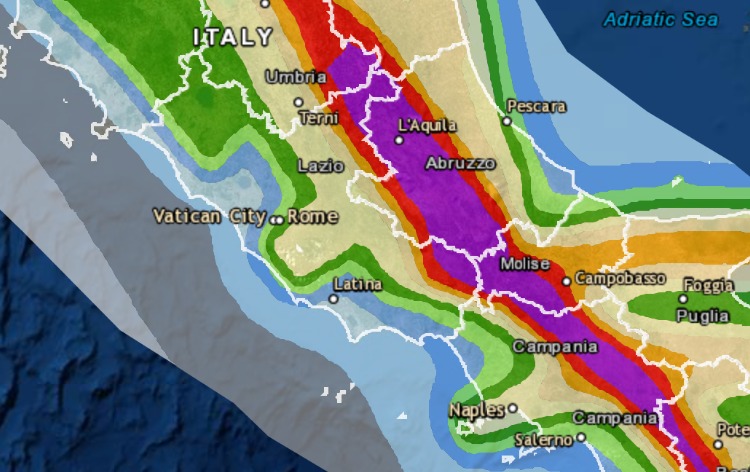
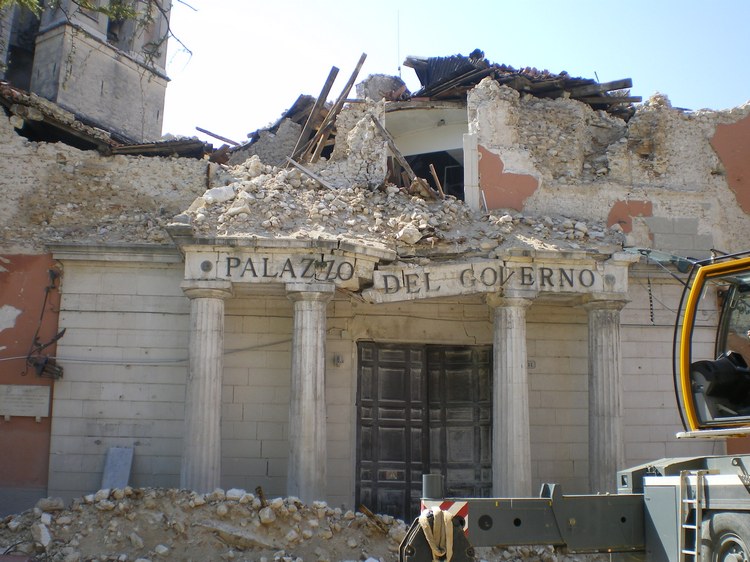
The L'Aquila earthquake occurred on April 6 2009 at 03:32:39 local time. The earthquake (Mw=6.3) was located in the central Italy region of Abruzzo. Much of the damage occurred in the capital city of L'Aquila, a city of approximate population 73000, although many small villages in the surrounding region of the middle Aterno river valley were also significantly damaged. In the weeks following the earthquake, the Geo-Engineering Extreme Events Reconnaissance (GEER) international team, comprised of members from different European countries and the U.S., was assembled to provide post-earthquake field reconnaissance. The GEER team focused on the geological, seismological, and geotechnical engineering aspects of the event. We describe the principal seismological findings related to this earthquake including moment tensors of the main shock and two triggered events, the aftershock pattern and its variation with time, tectonic deformations associated with the main shock, surface fault rupture, and the inferred fault rupture plane. We describe damage patterns on a village-to-village scale and on a more local scale within the city of L'Aquila. In many cases the damage patterns imply site effects, as neighbouring villages on rock and soil had significantly different damage intensities (damage more pronounced on softer sediments). The April 6 mainshock was the best-recorded event to date in Italy. We present metadata related to the recording sites and then present preliminary comparisons of the data to GMPEs. Those comparisons support the notion of faster distance attenuation in Italy relative to the average for active regions as reflected in NGA GMPEs. Several incidents of ground failure are then discussed, including a number of rockfalls and minor landslides. Perhaps the most significant incidents of ground failure occurred at Lake Sinizzo, for which we describe a number of slumps and spreads around the lake perimeter. This is documented using field observations as well as LIDAR and bathymetric data.