Fedele, A.; Somma, R.; Troise, C.; Holmberg, K.; De Natale, G.; Matano, F.
Time-Lapse Landform Monitoring in the Pisciarelli (Campi Flegrei-Italy) Fumarole Field Using UAV Photogrammetry.
Remote Sens. 2021, 13, 118.
Published: 31 December 2020
Abstract
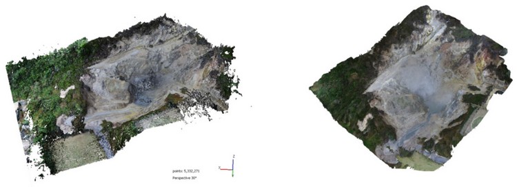
The utility of new imaging technologies to better understand hazardous geological environments cannot be overstated. The combined use of unmanned aerial vehicles (UAV) and digital photogrammetry (DP) represents a rapidly evolving technique that permits geoscientists to obtain detailed spatial data. This can aid in rapid mapping and analyses of dynamic processes that are modifying contemporary landscapes, particularly through the creation of a time series of digital data to help monitor the geomorphological evolution of volcanic structures. Our study comprises a short-term (in geological terms) monitoring program of the dynamic and diffuse Pisciarelli degassing structure caused by the interplay between intensive rainfall and hydrothermal activity. This area, an unstable fumarole field located several hundred meters east of the Solfatara Crater of the Campi Flegrei caldera (southern Italy), is characterized by consistent soil degassing, fluid emission from ephemeral vents, and hot mud pools. This degassing activity is episodically accompanied by seismic swarms and macroscopic morphology changes such as the appearance of vigorously degassing vents, collapsing landslides, and bubbling mud. In late-2019 and 2020, we performed repeated photogrammetric UAV surveys using the Structure from Motion (SfM) technique. This approach allowed us to create dense 3D point clouds and digital orthophotos spanning one year of surveys. The results highlight the benefits of photogrammetry data using UAV for the accurate remote monitoring and mapping of active volcanoes and craters in harsh and dangerous environments.
KEYWORDS:
UAV; drone; structure from motion; time-lapse; photogrammetry; fumarole field
This is an Open Access article distributed under the terms of the Creative Commons Attribution License (http://creativecommons.org/licenses/by/4.0/), which permits unrestricted use, distribution, and reproduction in any medium, provided the original work is properly cited.
Open Access Article | Time-Lapse Landform Monitoring in the Pisciarelli (Campi Flegrei-Italy) Fumarole Field Using UAV Photogrammetry